Buenos Aires, by Noelia Diaco. Photo is not visible, used only for sharing on social networks.

Hiking in Torres del Paine: part 1

March 27, 2012
Us with the Torres del Paine in the background.
It’s now Day 9 of our trip and we’ve finally made it to Torres del Paine national park in Chile. The park is a world-famous hiking destination and one of the most popular in South America. We chose to do the “W” Trek, the shorter of the park’s two most-well known hikes at about 75 kilometers. We had five days and five nights to do the whole thing and were carrying all our gear and our food on our backs.

Day 1: Camping Las Torres to Campamento Las Torres (9km)

camping las torres torres del paine chile

Our route was essentially a “W” (duh). Up one arm of the “W” the first day. The second day included a side trek to the Torres del Paine, which give the park its name, then down to the middle arm of the “W.” Up the middle on Day 3, up the final arm on Day 4, then back out of the park on Day 5.

Map: How to hike the "W" in Torres del Paine

Unfortunately, we didn’t get off to the best start. It rained the first night (at least our tent was still holding up — we met two Israeli guys who were using rain jackets to keep water out of their tent, which was built for the Negev desert). And though we fortunately didn’t get soaked the first day of hiking, the clouds didn’t lift at all and there was almost nothing to see.

But the idea was mostly to get up to the campsite so we could rise early the next morning to see the light hit the towers at sunrise. We made it to the camp in plenty of time, unloaded, and started to make dinner when we discovered our stove had broken! (It's a liquid-fuel pump that relies on a pressurized fuel bottle to work, and the pump was busted.) Bad news. We managed to borrow one from the park ranger for the night, but weren’t sure what we would do about the rest of the hike.

Day 2: Campamento Las Torres to Mirador Las Torres to Camping Las Torres (13km)

At sunrise the next morning, we were not at the towers but asleep in our tent, which had begun to leak. Since it was still cloudy and raining and since we now didn’t have a stove, we re-evaluated our entire plan. Instead of rushing out that morning, we hung around camp hoping the clouds would eventually clear so we could get a view of the Torres.


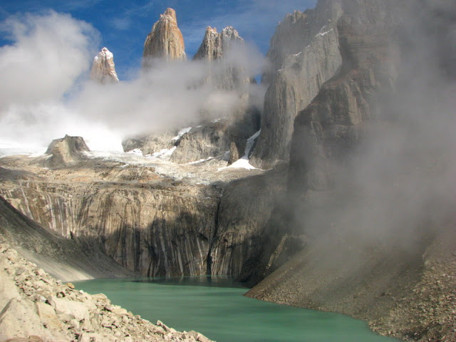
They did, and we were glad we waited around, because getting up there was one of the best parts of the hike.

torres del paine patagonia chile

torres del paine lake patagonia chile

Then we headed halfway back down to one of the refugios (private lodges in the park that offer food and beds for a hefty price), hoping we could rent a stove there. They didn’t have any so we continued back to base. Long story short about the stove: We were carrying a liquid one, and after it broke, we bought a gas canister and mooched a stove from fellow hikers the rest of the way. And starting with Antonio (a nice Chilean who was hiking the “Circuit” on his own), everyone was thankfully supernice about sharing.
Valle Ascencio torres del paine national park

Day 3: Camping Las Torres to Refugio Cuernos (11km)

We were now back on track with the official hike, having solved the stove problem. The “W” trek is designed so that the highlights basically correspond with the tips of the “W.” Since we were traveling from one arm to the next arm today, there weren’t a lot of highlights, just a large turquoise blue lake, some tall mountains, and a gradual rolling trail.

hike to los cuernos torres del paine


Lago Nordenskjold Torres del Paine national park

 It was a nice pleasant day, not too tiring, and we reached our campsite in plenty of time to make a pasta, sausage, onion, and garlic stir-fry for dinner, with a pisco sour from the refugio. If you think that sounds good as a normal dinner, think how delicious we found it after on our third night of camping. Yummy.


- Steph

Keep reading ...

Getting to Torres del Paine

The wonderful weather on the drive to Torres del Paine.


There’s not much to report from the next couple of days, which we mostly spent traveling from El Calafate in Argentina to the Torres del Paine national park in Chile. To get to Torres del Paine, we had to go through Puerto Natales, the third of three towns we visited on the trip and by far our least favorite.

The town’s vibe was decidedly unfriendly. The other backpackers were plenty nice, but the actual inhabitants never seemed to smile. The town was rundown and sketchy after dark. Interestingly, it seemed to be up to each individual restaurant whether to allow smoking. In some, it was expressly allowed; in others, it was prohibited. Happily, there were pisco sours on all the menus, though we couldn't escape the really bad music that seemed to be playing everywhere we went in Chile (even the customs agents at the border were watching pop music videos on TV while working).

Compared to Puerto Natales, El Calafate appeared upbeat, nice and alive — but very touristy. The shopping area on the main street looked like Fisherman’s Wharf in San Francisco with its log cabin-style shops. There were always cab drivers hanging around the bus stop, offering to take you to the glacier and the restaurants seemed very pricey (and with English menus, usually not a good sign). There was even a store named “El Turista”!

Which leaves El Chalten as our favorite town by far. Small, still being built, with plenty of open space and a very rustic, mountain-y feel. It’s the one town to which I could imagine returning, even just to spend a relaxing week being outdoors and drinking good beer.

The other unfortunate fact about Puerto Natales is that it’s two hours by bus from Torres del Paine, which meant we had a six-hour bus ride across the border, then a night in Puerto Natales and another bumpy ride to the park the next day. We had hoped to spend only about 15 hours in Puerto Natales, but we had to delay our departure to rent a new pack for me. But by the next afternoon, we were on our way to Torres del Paine.

(For future travelers, see our earlier posts about the logistics of getting from El Calafate to Torres del Paine.)

- Steph

Keep reading...

Calafate and the Perito Moreno Glacier

March 26, 2012
Start from the beginning of our Patagonian adventure.
Chalten's government functions fit
in two rooms, 2 hrs/day, 2 days/week

From El Chalten we took a bus back to El Calafate. That’s a much bigger town on the southern end of the same park (Parque Nacional de Los Glacieres) as El Chalten. We had flown into the El Calafate airport but immediately left for El Chalten and hadn’t spent time there yet.

More on the town of El Calafate in a bit, but first, the main reason we stopped over was to see the Perito Moreno Glacier. We woke early on Day 7 and got picked up for the tour by a minibus, which converged with several others to transfer their passengers from the town’s many B&Bs onto a big bus with a guide. At the park entrance, even though we had already trekked the other end, we had to pay an entrance fee (which differed by nationality). As the glacier came into view, everyone ooh’d on command. From far away it just looked like the big block of ice in all the posters. It wasn’t until we got closer up (for an hour on the walkways and then a trek on the ice itself) that we realized how awesome the site was.


Most glaciers are shrinking these days, but Perito Moreno is one of the few stable ones. In the warmer months (this being the end of summer) the water melts slowly, and blocks of ice constantly fall off into the lake.


In the colder months the rain freezes and the glacier grows again, maintaining an overall stability (at least since it’s been studied in the early 20th century). Every decade or so, water pressure builds up on the face and causes a massive rupture — and such an event had occurred only a week before, so the guides were still buzzing with excitement.

The chunk on the right shows where the glacier ended a week earlier, before the rupture


We took a boat around to the south face and had lunch at a refugio there. Then we strapped crampons onto our shoes and started hiking across the ice. The crampons took a few moments to get used to, with every step feeling so solid, but it made the ice feel as stable as any trail. As we set out, we watched an apparently famous female Argentine athlete arrive in a dinghy with a crew and swim across the frigid lake.

One of my favorite parts of this whole trip was seeing all the geology on different scales. Not too long ago, much of today’s land masses were covered with ice, and we got to see up-close the micro phenomena that in aggregate produce massive events like glacial ruptures and rising sea levels. The ice forms crystals, which make the surface feel granular, and refracts the sunlight in such a way as to make the terrain appear blue. Streams of melted water flow across the ice causing crevasses and sinkholes. In a counter-intuitive way (compared to hiking on a frozen lake), the surface could be liquid but underneath it’s always solid ice. (Some trekkers go much farther to where snow covers the ice and the sinkholes alike; there falling through is a real danger, so ropes are used.)

The tour company (an authorized monopoly which charges accordingly) has two treks, a shorter one (~1.5hrs on the ice) and longer (4 hrs). We did the shorter one, mostly to rest in between the harder treks on solid ground, and didn’t feel like we missed anything. We didn’t care for the regimented schedule, though - now walk here, now eat lunch, now wait around - trekking on our own time was a lot more fun.

At the end of the ice trek, we reached a table and chest, where a bottle of Jameson was poured into tumblers, over ice picked right there with the guide’s ice-pick, and enjoyed it with alfajores.


A word if you’re doing the trek: The temperature fluctuated all day, probably accentuated by the sun reflecting off the ice, so wearing the right layers was tricky. Also don’t forget sunscreen! - we did, and got very burnt.

Back in town...
We stayed at the Hospedaje Lautaro, three blocks from the main road (with all the tourist shops, including an area modeled after Fisherman’s Wharf). Like a lot of B&B’s, Lautaro is family-owned and operated, with two adjacent houses and the owners (parents Dario and Belen and a little girl) living in part of one. Dario is a chef and they offer homemade dinners (kind of like a puerta cerrada restaurant), which we ate for three nights (on days 6, 7, and 15) because it was so good. They also offered laundry service, which we badly needed.

The weather in town was beautiful, so before dinner the first night we had ice cream outside (three variations on coffee, our favorite flavor) and did other errands. We reserved tickets for the glacier trek the next day. We looked for better camping cookware - all we had was a single pot which was meant for one person and made even pasta for two difficult, not to mention pancakes - but the one store that had a good set was too expensive. Then dinner by Dario — steak (huge, juicy, perfectly medium-rare), risotto with dried pine mushrooms hydrated with red wine (amazing), and salad (wonderful after our vegetable-deprived trail diet). The only shortcoming on the menu was the wine - no good Malbecs - so we had a bottle in our room before and after the meal. We ate with a German woman who had taken several months off of work to travel around South America.

Back in town after the glacier, exhausted, we had another amazing dinner by Dario (this time fettuccine with mushroom sauce), packed for the morning, and fell asleep.

Next stop: Chile!

- Ben


Keep reading...


My very first pie

March 25, 2012
Apple pie ...

... for Ben's birhday.

- Steph

El Chalten: Conclusions

March 23, 2012


Start from the beginning of our Patagonian adventure.

So why did we love hiking near El Chalten so much? First, the scenery is beautiful the entire time. Hiking in New England often means hours of hiking in thick forest, with the only real payoff at the end once you get above treeline. In El Chalten, there are a few really beautiful moments (Laguna de los Tres, the views of Mount Fitz Roy), but there are a million smaller breathtaking views all along the way. There’s no sense of rushing to see your destination. As the cliche goes, it’s the journey that’s important.

Second, you can design your own itinerary easily, depending on how many days you have, what you want to see, and how fast you’re going. The campsites aren’t so far apart to demand covering certain distances on certain days. And most importantly, it’s easy to set up camp and then head out on day hikes. We spent our first two nights at Campamento Poincenot, which meant we could spend a whole day without our heavy packs. It made the hiking much more enjoyable.

Finally, and more of this once we get to Torres del Paine, hiking in El Chalten isn’t commercialized. The park starts right outside of the town, so you head there on your own terms. There are no lodges or stores inside the park, just basic campgrounds meant to provide shelter from the wind and rain.

But for now, on to El Calafate...

el chalten town argentina
El Chalten


El Chalten: Laguna torre, and a glacier!

laguna torre glacier torre el chalten
Glacier Torre, the first of several glaciers on our trip.

Start from the beginning of our Patagonian adventure.

One of the best parts about hiking in El Chalten is that you can do a lot of the best hikes with only a daypack. So on our last morning, we loaded up light packs and headed to the Mirador Maestri, above the Laguna Torre and Glacier Torre and supposedly boasting grandstand views of Cerro Torre, the second-biggest peak in the park.

We hiked along the moraine wall of the glacier, and for the first of many times on this trip, I wish I remembered more from my eighth-grade geology class. I definitely used to know what a moraine wall is, and my topographical map-reading skills have declined significantly since I was 14.

moraine wall glacier torre
Me on the moraine wall

After making it most of the way to the mirador (lookout), we turned back at the preset time (it was drilled into me that you should always have a turnback time in mind, so you don’t get stuck out too late), but I gathered that not everyone followed this principle. Also, Cerro Torre appeared ensconced behind a permanent cloud, which appeared solid like an ice peak. So we figured we didn’t need to rush to the top just to see a cloud.

laguna torre glacier torre iceberg

We packed up camp and headed the 9.5 kilometers back to El Chalten. The trek was long, and at this point, our packs were very painful. I ended up ditching mine for the next section of the hike, it hurt my back so much, which meant that for now, Ben had most of the weight. Luckily the terrain was beautiful, with the mountains behind us, a river ravine off to our right, and Cerro Torre still lurking behind the cloud (we finally glimpsed it for about five seconds, before it disappeared again). 
We were exhausted by the time the town appeared, at about 6 p.m., and though we had considered camping, we checked back in at Latitud 49, preferring showers and a bed. We ate a hearty meal at the pizza place (Patagonia is the only place we’ve been in Argentina with good craft beer), including salad (vegetables!), then turned in for the night.

And that was it for El Chalten. The next day it was off to El Calafate and the Perito Moreno glacier.

rainbow camping el chalten

- Steph


Keep reading...